Skip to search
Skip to main content
Digital Commonwealth
Sign Up / Log In
Search for
Search
Search
Search
Basic
Advanced
Explore
Map
Collections
Institutions
Formats
For Educators
Primary Source Sets
Lesson Plans
Using Primary Sources
Searching Digital Commonwealth
For Institutions
Join Digital Commonwealth
Conferences, Trainings, & Events
How to Contribute Collections
Digitization Services
Board & Committees
Frequently Asked Questions
About
About Digital Commonwealth
News & Announcements
Copyright & Terms of Use
Harmful Content Statement
Partners
API
Contact Us
Boston Public Library
Norman B. Leventhal Map Center Collection
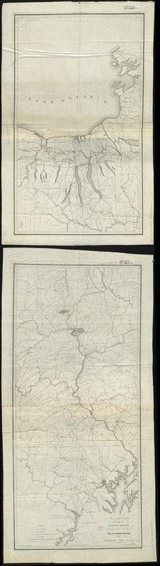
Map of the country embracing the several routes examined with a view to a national road from Washington to Lake Ontario
Map of the country embracing the several routes examined with a view to a national road from Washington to Lake Ontario
×
Item Information
Title:
Map of the country embracing the several routes examined with a view to a national road from Washington to Lake Ontario
Creator:
Harrison, F.
Name on Item:
compiled by F. Harrison Jr. ; drawn by A. J. Stansbury.
Date:
[1830–1839]
Format:
Maps/Atlases
Location:
Boston Public Library
Norman B. Leventhal Map Center
Collection (local):
Norman B. Leventhal Map Center Collection
Subjects:
Hydrology--Middle Atlantic States--Maps
Roads--Middle Atlantic States--Maps
Middle Atlantic States--Maps
Maryland--Maps
New York (State)--Maps
Pennsylvania--Maps
Places:
Pennsylvania
Maryland
Middle Atlantic
(area)
New York
Extent:
1 map on 2 sheets ; 162 x 40 cm., on sheets 71 x 40 cm. and 92 x 40 cm.
Permalink:
https://ark.digitalcommonwealth.org/ark:/50959/7h14b211k
Terms of Use:
No known copyright restrictions.
No known restrictions on use.
Publisher:
Georgetown D.C : W. Harrison
Scale:
Scale [ca. 1:332,000]
Language:
English
Notes:
Prime meridian: Washington, D.C.
Relief shown by hachures.
Notes (date):
This date is inferred.
Identifier:
06_01_008722
Call #:
G3791.P2 1830 .H37x
Barcode:
39999065656678
show more...
View MODS XML
More Like This
The new war map of Virginia, Maryland & Pennsylvania
Map of the State of New York with part of the states of ...
A survey of the empire group : with a complete distance table, a ...
A survey of the empire group : with a complete distance table, a ...
Find More Like This >>
Tools
Share
Facebook
Pinterest
X
Reddit
Tumblr
Email
Copy link
Add to Folder
Questions/Comments
Cite This Item
IIIF Manifest
Downloads
Primary (full resolution, uncompressed)
(TIF, 219 MB)
Large (full resolution)
(JPEG, 18.4 MB)
Medium
(JPEG, 81.5 KB)