Skip to search
Skip to main content
Digital Commonwealth
Sign Up / Log In
Search for
Search
Search
Search
Basic
Advanced
Explore
Map
Collections
Institutions
Formats
For Educators
Primary Source Sets
Lesson Plans
Using Primary Sources
Searching Digital Commonwealth
For Institutions
Join Digital Commonwealth
Conferences, Trainings, & Events
How to Contribute Collections
Digitization Services
Board & Committees
Frequently Asked Questions
About
About Digital Commonwealth
News & Announcements
Copyright & Terms of Use
Harmful Content Statement
Partners
API
Contact Us
Library and Archives Canada
American Revolutionary War-Era Maps (Collection of Distinction)
/
Library and Archives Canada Collection
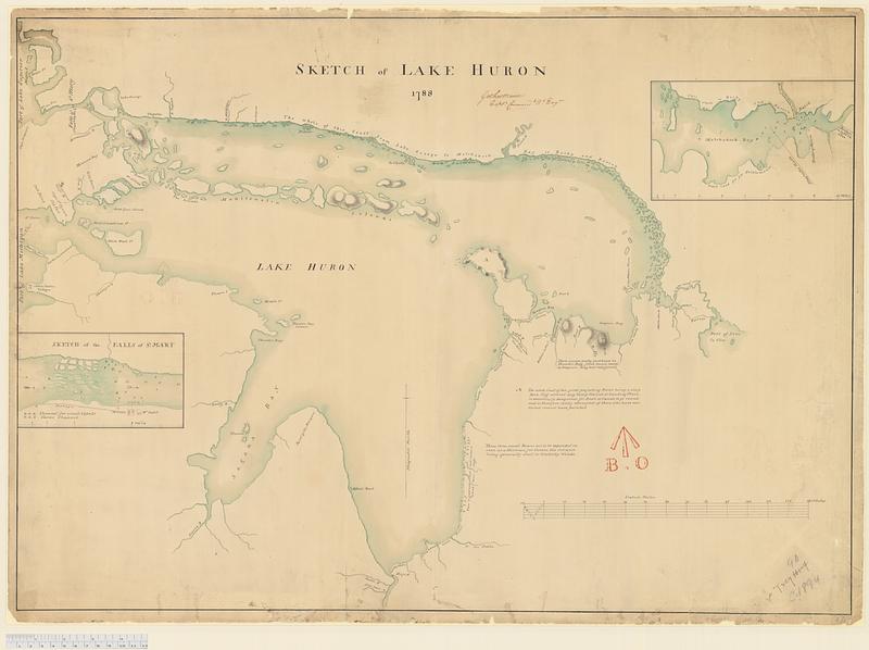
Sketch of Lake Huron
Sketch of Lake Huron
×
Item Information
Title:
Sketch of Lake Huron
Cartographer:
Mann, Gother, 1747-1830
Name on Item:
Gother Mann, Captn. Commandg. Rl. Engrs.
Date:
1788
Format:
Maps/Atlases
Genre:
Manuscript maps
Location:
Library and Archives Canada
Collection (local):
Library and Archives Canada Collection
Subjects:
Huron, Lake (Mich. and Ont.)--Maps
Places:
Huron, Lake
Extent:
1 manuscript map : hand color ; 52 x 74 cm
Permalink:
https://ark.digitalcommonwealth.org/ark:/50959/8c97pq34j
Terms of Use:
Copyright expired. Contact host institution to download image.
Contact host institution for more information.
Place of origin:
[Québec]
Language:
English
Referenced by:
Catalog record
Notes:
Board of Ordnance Stamp.
Identifier:
e011182195
Barcode:
4169996
show more...
View MODS XML
More Like This
The fifteenth section no. I. Lake Huron 1820 & 1822
General chart of Lake Huron
Harbor of Refuge, Sand Beach, Lake Huron
Northwestern part of Lake Huron
Find More Like This >>
Tools
Share
Facebook
Pinterest
X
Reddit
Tumblr
Email
Copy link
Add to Folder
Questions/Comments
Cite This Item
IIIF Manifest