Skip to search
Skip to main content
Digital Commonwealth
Sign Up / Log In
Search for
Search
Search
Search
Basic
Advanced
Explore
Map
Collections
Institutions
Formats
For Educators
Primary Source Sets
Lesson Plans
Using Primary Sources
Searching Digital Commonwealth
For Institutions
Join Digital Commonwealth
Conferences, Trainings, & Events
How to Contribute Collections
Digitization Services
Board & Committees
Frequently Asked Questions
About
About Digital Commonwealth
News & Announcements
Copyright & Terms of Use
Harmful Content Statement
Partners
API
Contact Us
Boston Public Library
Norman B. Leventhal Map Center Collection
/
Urban Maps (Collection of Distinction)
/
American Revolutionary War-Era Maps (Collection of Distinction)
/
Boston and New England Maps (Collection of Distinction)
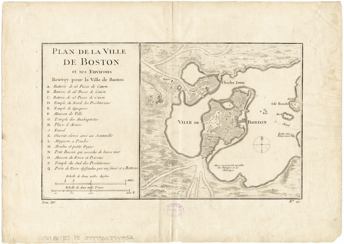
Plan de la ville de Boston et ses environs
Plan de la ville de Boston et ses environs
×
Item Information
Title:
Plan de la ville de Boston et ses environs
Date:
[1757]
Format:
Maps/Atlases
Location:
Boston Public Library
Norman B. Leventhal Map Center
Collection (local):
Norman B. Leventhal Map Center Collection
Subjects:
Boston (Mass.)--Maps--Early works to 1800
Boston Harbor (Mass.)--Maps--Early works to 1800
Places:
Boston Harbor
Suffolk (county)
>
Boston
Extent:
1 map ; 16 x 27 cm.
Permalink:
https://ark.digitalcommonwealth.org/ark:/50959/9s161959j
Terms of Use:
No known copyright restrictions.
No known restrictions on use.
Publisher:
Paris : Didot
Scale:
Scale ca. 1:44,000
Language:
English
Notes:
Depths shown by soundings.
Includes index to points of interest coded A-Q.
At lower margin: "Tom XIV no. 10."
Detached from: Prévost, A.F. Histoire générale des voyages, t. 14, p. 532. Paris : Didot, 1757.
Notes (date):
This date is inferred.
Identifier:
06_01_003271
Call #:
G3764.B6 1757 .P5
Barcode:
39999058999952
show more...
View MODS XML
More Like This
Boston, its environs and harbour, with the rebel works raised ...
Bowles's map of the seat of war in New England, comprehending the ...
Carte de la ville, baye et environs de Baston
Carte des environs de Boston, capitale de la Nlle. Angleterre en ...
Find More Like This >>
Tools
Share
Facebook
Pinterest
X
Reddit
Tumblr
Email
Copy link
Add to Folder
Questions/Comments
Cite This Item
IIIF Manifest
Downloads
Primary (full resolution, uncompressed)
(TIF, 145 MB)
Large (full resolution)
(JPEG, 12.1 MB)
Medium
(JPEG, 283 KB)