Skip to search
Skip to main content
Digital Commonwealth
Sign Up / Log In
Search for
Search
Search
Search
Basic
Advanced
Explore
Map
Collections
Institutions
Formats
For Educators
Primary Source Sets
Lesson Plans
Using Primary Sources
Searching Digital Commonwealth
For Institutions
Join Digital Commonwealth
Conferences, Trainings, & Events
How to Contribute Collections
Digitization Services
Board & Committees
Frequently Asked Questions
About
About Digital Commonwealth
News & Announcements
Copyright & Terms of Use
Harmful Content Statement
Partners
API
Contact Us
Boston Public Library
Norman B. Leventhal Map Center Collection
/
Urban Maps (Collection of Distinction)
/
Boston and New England Maps (Collection of Distinction)
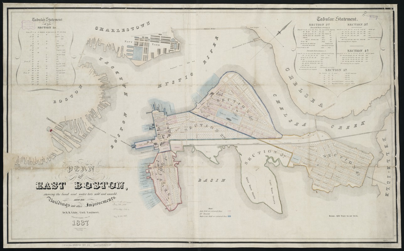
Plan of East Boston showing the land and water lots sold and unsold : also all buildings and other improvements
Plan of East Boston showing the land and water lots sold and unsold
×
Item Information
Title:
Plan of East Boston showing the land and water lots sold and unsold : also all buildings and other improvements
Creator:
Eddy, R. H. (Robert Henry), 1812-1887
Name on Item:
by R.H. Eddy ; drawn by T. Gosselin.
Date:
1837
Format:
Maps/Atlases
Location:
Boston Public Library
Norman B. Leventhal Map Center
Collection (local):
Norman B. Leventhal Map Center Collection
Subjects:
Real property--Massachusetts--Boston--East Boston--Maps
Land tenure--Massachusetts--Boston--East Boston--Maps
East Boston (Boston, Mass.)--Maps
Places:
Suffolk (county)
>
Boston
>
East Boston
Extent:
1 map : col. ; 68 x 113 cm.
Permalink:
https://ark.digitalcommonwealth.org/ark:/50959/9s161f41x
Terms of Use:
No known copyright restrictions.
No known restrictions on use.
Publisher:
Boston, Mass : T. Moore's Lithography
Scale:
Scale 1:4,800.
Language:
English
Notes:
Oriented with north toward the upper right.
"On stone by J.E. Moody."
Includes tabular statements of lots.
Identifier:
06_01_003886
Call #:
G3764.B6:2E2G46 1837 .E3
Barcode:
39999059002525
show more...
View MODS XML
More Like This
Plan of property of the National Dock & Warehouse Co. East Boston
Atlas of the city of Boston : Charlestown and East Boston : from ...
Atlas of the city of Boston : Charlestown and East Boston : from ...
Atlas of the city of Boston : East Boston : from actual surveys ...
Find More Like This >>
Tools
Share
Facebook
Pinterest
X
Reddit
Tumblr
Email
Copy link
Add to Folder
Questions/Comments
Cite This Item
IIIF Manifest
Downloads
Primary (full resolution, uncompressed)
(TIF, 157 MB)
Large (full resolution)
(JPEG, 13.2 MB)
Medium
(JPEG, 292 KB)