Skip to search
Skip to main content
Digital Commonwealth
Sign Up / Log In
Search for
Search
Search
Search
Basic
Advanced
Explore
Map
Collections
Institutions
Formats
For Educators
Primary Source Sets
Lesson Plans
Using Primary Sources
Searching Digital Commonwealth
For Institutions
Join Digital Commonwealth
Conferences, Trainings, & Events
How to Contribute Collections
Digitization Services
Board & Committees
Frequently Asked Questions
About
About Digital Commonwealth
News & Announcements
Copyright & Terms of Use
Harmful Content Statement
Partners
API
Contact Us
Boston Public Library
Norman B. Leventhal Map Center Collection
/
Boston and New England Maps (Collection of Distinction)
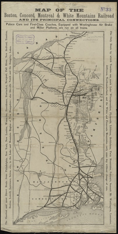
Map of the Boston, Concord, Montreal & White Mountains Railroad and its principal connections
Map of the Boston, Concord, Montreal & White Mountains Railroad and its principal connections
×
Item Information
Title:
Map of the Boston, Concord, Montreal & White Mountains Railroad and its principal connections
Title (alt.):
White Mountains by the Boston, Concord, Montreal and White Mountains R. R
Creator:
Rand, Avery & Co
Date:
1882
Format:
Maps/Atlases
Location:
Boston Public Library
Norman B. Leventhal Map Center
Collection (local):
Norman B. Leventhal Map Center Collection
Subjects:
Boston, Concord, Montreal, and White Mountains Railroad
Railroads--New England--Maps
New England--Maps
Places:
New England
(area)
Extent:
1 map ; 60 x 28 cm., folded to 18 x 9 cm.
Permalink:
https://ark.digitalcommonwealth.org/ark:/50959/cj82kp23z
Terms of Use:
No known copyright restrictions.
No known restrictions on use.
Publisher:
Boston : Rand, Avery & Co.
Scale:
Scale [ca. 1:1,200,000]
Language:
English
Notes:
Relief shown by hachures.
Includes text in margins.
Text, ill., and timetables on verso.
Identifier:
06_01_009214
Call #:
G3721.P3 1882 .R36x
Barcode:
39999065660621
show more...
View MODS XML
More Like This
ABC pathfinder railway guide map : eastern division
Boston Clinton Fitchburg and Mansfield Framingham Lowell ...
Ensign, Bridgman & Fanning's rail road map of the United States, ...
E.P. Dutton & Co.'s railroad, steam boat & stage route map of New ...
Find More Like This >>
Tools
Share
Facebook
Pinterest
X
Reddit
Tumblr
Email
Copy link
Add to Folder
Questions/Comments
Cite This Item
IIIF Manifest
Downloads
Primary (full resolution, uncompressed)
(TIF, 94.3 MB)
Large (full resolution)
(JPEG, 7.92 MB)
Medium
(JPEG, 148 KB)