Skip to search
Skip to main content
Digital Commonwealth
Sign Up / Log In
Search for
Search
Search
Search
Basic
Advanced
Explore
Map
Collections
Institutions
Formats
For Educators
Primary Source Sets
Lesson Plans
Using Primary Sources
Searching Digital Commonwealth
For Institutions
Join Digital Commonwealth
Conferences, Trainings, & Events
How to Contribute Collections
Digitization Services
Board & Committees
Frequently Asked Questions
About
About Digital Commonwealth
News & Announcements
Copyright & Terms of Use
Harmful Content Statement
Partners
API
Contact Us
Boston Public Library
Norman B. Leventhal Map Center Collection
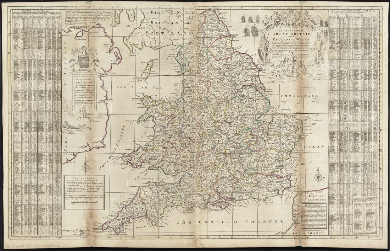
The south part of Great Britain, called England and Wales
The south part of Great Britain, called England and Wales
×
Item Information
Title:
The south part of Great Britain, called England and Wales
Creator:
Moll, Herman, d. 1732
Name on Item:
according to ye most approved surveys, and accurate observations by Herman Moll.
Date:
[1750?–1759?]
Format:
Maps/Atlases
Location:
Boston Public Library
Norman B. Leventhal Map Center
Collection (local):
Norman B. Leventhal Map Center Collection
Subjects:
England--Maps--Early works to 1800
Wales--Maps--Early works to 1800
Places:
Wales
England
Extent:
1 map : hand col. ; 60 x 97 cm.
Permalink:
https://ark.digitalcommonwealth.org/ark:/50959/cj82kt110
Terms of Use:
No known copyright restrictions.
No known restrictions on use.
Publisher:
[London] : Printed for H. Moll ... [by] I. Bowles & Son ... and Tho. Bowles ; sold by Robt. Sayer ... and by John King
Scale:
Scale [ca. 1:1,080,000]
Language:
English
Notes:
Relief shown pictorially.
Includes index with other information about the town, such as market days and distance from London.
Dedicated to Francis, Lord Viscount Rialton.
Appears in Moll's The world described, [1709-1736], plate 17.
Identifier:
06_01_009675
Call #:
G1015 .M65 1709
Barcode:
30000003877372
show more...
View MODS XML
More Like This
An accurate map of England and Wales with the principal roads from ...
England and Wales accurately delineated from the latest surveys
A new map of England and Wales with the direct and cros roads also ...
A new most accurate & complete map of all the direct and the ...
Find More Like This >>
Tools
Share
Facebook
Pinterest
X
Reddit
Tumblr
Email
Copy link
Add to Folder
Questions/Comments
Cite This Item
IIIF Manifest
Downloads
Primary (full resolution, uncompressed)
(TIF, 287 MB)
Large (full resolution)
(JPEG, 24.1 MB)
Medium
(JPEG, 486 KB)