Skip to search
Skip to main content
Digital Commonwealth
Sign Up / Log In
Search for
Search
Search
Search
Basic
Advanced
Explore
Map
Collections
Institutions
Formats
For Educators
Primary Source Sets
Lesson Plans
Using Primary Sources
Searching Digital Commonwealth
For Institutions
Join Digital Commonwealth
Conferences, Trainings, & Events
How to Contribute Collections
Digitization Services
Board & Committees
Frequently Asked Questions
About
About Digital Commonwealth
News & Announcements
Copyright & Terms of Use
Harmful Content Statement
Partners
API
Contact Us
Boston Public Library
Norman B. Leventhal Map Center Collection
/
Urban Maps (Collection of Distinction)
/
Boston and New England Maps (Collection of Distinction)
Plan of Boston
Plan of Boston
×
Item Information
Title:
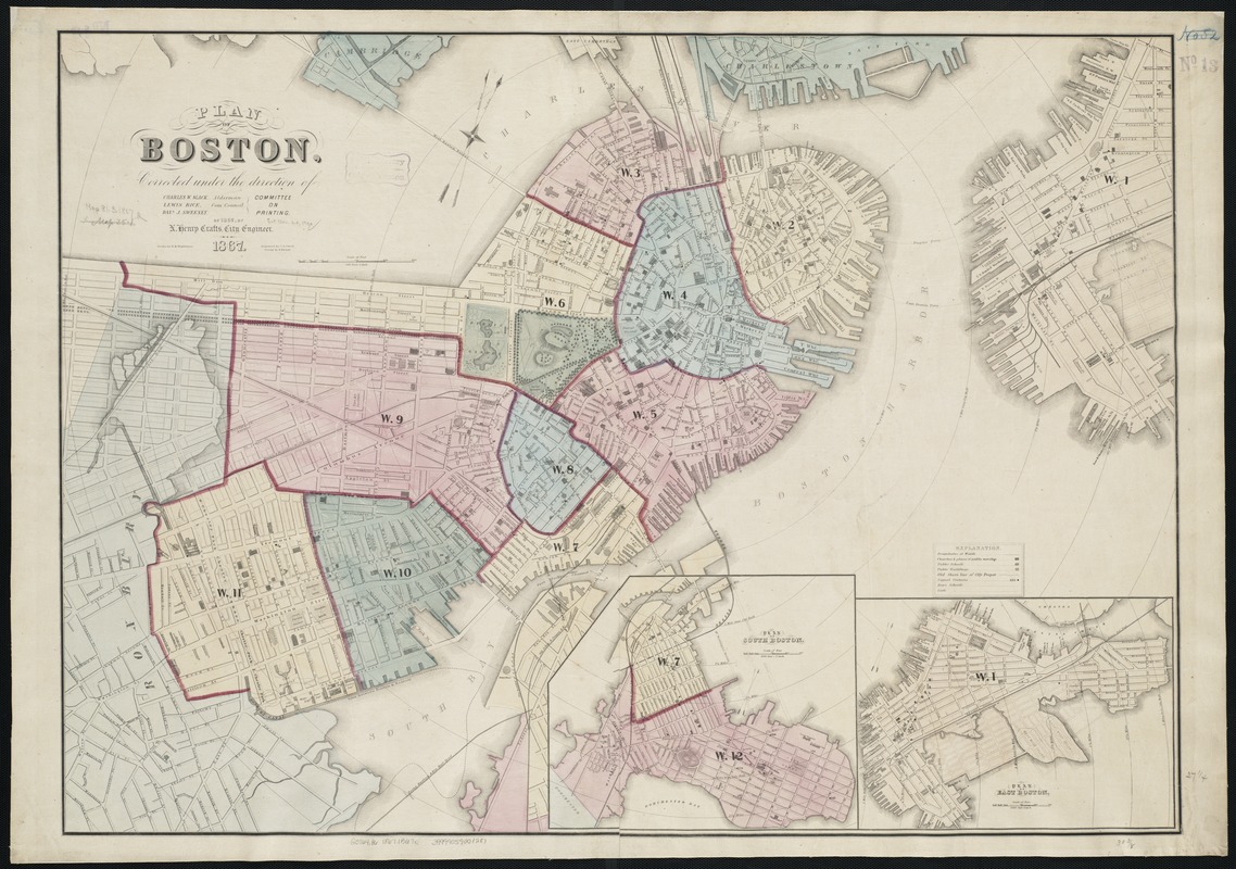
Plan of Boston
Creator:
Boston (Mass.). Engineering Dept
Name on Item:
corrected under the direction of Committee on Printing of 1867, by N. Henry Crafts ; drawn by H.M. Wightman ; engraved by C.A. Swett.
Date:
1867
Format:
Maps/Atlases
Location:
Boston Public Library
Norman B. Leventhal Map Center
Collection (local):
Norman B. Leventhal Map Center Collection
Subjects:
Boston (Mass.)--Maps
Places:
Suffolk (county)
>
Boston
Extent:
1 map : col. ; 69 x 97 cm.
Permalink:
https://ark.digitalcommonwealth.org/ark:/50959/cj82m171v
Terms of Use:
No known copyright restrictions.
No known restrictions on use.
Publisher:
Boston, Mass : [Engineering Dept.]
Scale:
Scale 1:6,000.
Language:
English
Notes:
Relief shown by hachures.
Oriented with north toward the upper right.
Insets: Plan of South Boston and Plan of East Boston.
Distance from City Hall depicted by cocentric circles.
"A. Meisel, Printer."
Identifier:
06_01_003481
Call #:
G3764.B6 1867 .B672
Barcode:
39999059001287
show more...
View MODS XML
More Like This
Annexation map
Atlas of the city of Boston : Boston proper : from actual surveys ...
Atlas of the city of Boston : Boston proper and Back Bay : from ...
Atlas of the city of Boston : Boston proper and Back Bay : from ...
Find More Like This >>
Tools
Share
Facebook
Pinterest
X
Reddit
Tumblr
Email
Copy link
Add to Folder
Questions/Comments
Cite This Item
IIIF Manifest
Downloads
Primary (full resolution, uncompressed)
(TIF, 198 MB)
Large (full resolution)
(JPEG, 16.7 MB)
Medium
(JPEG, 324 KB)
GeoTIFF (georeferenced)
(TIF, 83.5 MB)