Skip to search
Skip to main content
Digital Commonwealth
Sign Up / Log In
Search for
Search
Search
Search
Basic
Advanced
Explore
Map
Collections
Institutions
Formats
For Educators
Primary Source Sets
Lesson Plans
Using Primary Sources
Searching Digital Commonwealth
For Institutions
Join Digital Commonwealth
Conferences, Trainings, & Events
How to Contribute Collections
Digitization Services
Board & Committees
Frequently Asked Questions
About
About Digital Commonwealth
News & Announcements
Copyright & Terms of Use
Harmful Content Statement
Partners
API
Contact Us
Boston Public Library
Norman B. Leventhal Map Center Collection
/
Boston and New England Maps (Collection of Distinction)
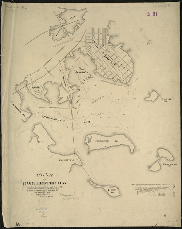
Plan of Dorchester Bay showing its surroundings together with current observations to illustrate the effect of discharging sewage at cow pasture point
Plan of Dorchester Bay showing its surroundings together with current observations to illustrate the effect of discharging sewage at cow pasture point
×
Item Information
Title:
Plan of Dorchester Bay showing its surroundings together with current observations to illustrate the effect of discharging sewage at cow pasture point
Creator:
Wilson, Henry W.
Name on Item:
Henry W. Wilson, engineer.
Date:
1880–1890
Format:
Maps/Atlases
Manuscripts
Location:
Boston Public Library
Norman B. Leventhal Map Center
Collection (local):
Norman B. Leventhal Map Center Collection
Subjects:
Dorchester Bay (Boston, Mass.)--Maps, Manuscript
Places:
Suffolk (county)
>
Dorchester Bay
Extent:
1 ms. map ; on sheet 71 x 57 cm.
Permalink:
https://ark.digitalcommonwealth.org/ark:/50959/cj82m237r
Terms of Use:
No known copyright restrictions.
No known restrictions on use.
Scale:
Scale 1:12,000.
Language:
English
Notes:
Manuscript map.
Depths shown by soundings.
Shows Harbor Commissioners Line and directions of the currents.
Identifier:
06_01_005876
Call #:
G3762.D6 1880 .W55
Barcode:
39999059018133
show more...
View MODS XML
More Like This
The 100th anniversary map of Abraham Lincoln's visit to ...
1630 shoreline
1879. Progress map of the U.S. Geographical Surveys west of the ...
1903 Map of Salem and surrounding places
Find More Like This >>
Tools
Share
Facebook
Pinterest
X
Reddit
Tumblr
Email
Copy link
Add to Folder
Questions/Comments
Cite This Item
IIIF Manifest
Downloads
Primary (full resolution, uncompressed)
(TIF, 150 MB)
Large (full resolution)
(JPEG, 12.6 MB)
Medium
(JPEG, 148 KB)