Skip to search
Skip to main content
Digital Commonwealth
Sign Up / Log In
Search for
Search
Search
Search
Basic
Advanced
Explore
Map
Collections
Institutions
Formats
For Educators
Primary Source Sets
Lesson Plans
Using Primary Sources
Searching Digital Commonwealth
For Institutions
Join Digital Commonwealth
Conferences, Trainings, & Events
How to Contribute Collections
Digitization Services
Board & Committees
Frequently Asked Questions
About
About Digital Commonwealth
News & Announcements
Copyright & Terms of Use
Harmful Content Statement
Partners
API
Contact Us
Boston Public Library
Norman B. Leventhal Map Center Collection
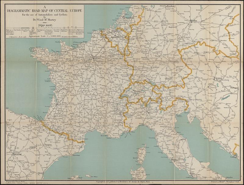
A diagrammatic road map of Central Europe : for the use of automobilists and cyclists
A diagrammatic road map of Central Europe
×
Item Information
Title:
A diagrammatic road map of Central Europe : for the use of automobilists and cyclists
Cartographer:
McMurtry, Wood
Name on Item:
by Dr. Wood McMurtry ; engraved by Forest
Date:
[1910–1918]
Format:
Maps/Atlases
Location:
Boston Public Library
Norman B. Leventhal Map Center
Collection (local):
Norman B. Leventhal Map Center Collection
Subjects:
Europe, Central--Maps
Roads--Europe, Central--Maps
Places:
Central Europe
(area)
Extent:
1 map : cloth, color ; 49 x 65 cm, folded in cover 18 x 11 cm
Permalink:
https://ark.digitalcommonwealth.org/ark:/50959/f7625w223
Terms of Use:
No known copyright restrictions.
No known restrictions on use.
Publisher:
Paris : Brentano's
Edition:
Second, revised edition
Scale:
Scale approximately 1:3,000,000
Language:
English
Notes:
Shows types of roads and distances.
Oriented with north towards the upper right.
"Printed on Dean's 'Washphast' cloth."
Notes (date):
This date is inferred.
Identifier:
06_01_016711
Call #:
G6031.P2 1910z .M36
Barcode:
39999085950416
show more...
View MODS XML
More Like This
The A.A.A. key road map of continental Europe
Bartholomew's contour motoring map of Central Europe showing the ...
Deutschland, königr. der Niederlande, kgr. Belgien und die ...
Post- und reise-karte von Deutschland und den anliegenden ländern ...
Find More Like This >>
Tools
Share
Facebook
Pinterest
X
Reddit
Tumblr
Email
Copy link
Add to Folder
Questions/Comments
Cite This Item
IIIF Manifest
Downloads
Primary (full resolution, uncompressed)
(TIF, 72.2 MB)
Large (full resolution)
(JPEG, 6.06 MB)
Medium
(JPEG, 119 KB)