Skip to search
Skip to main content
Digital Commonwealth
Sign Up / Log In
Search for
Search
Search
Search
Basic
Advanced
Explore
Map
Collections
Institutions
Formats
For Educators
Primary Source Sets
Lesson Plans
Using Primary Sources
Searching Digital Commonwealth
For Institutions
Join Digital Commonwealth
Conferences, Trainings, & Events
How to Contribute Collections
Digitization Services
Board & Committees
Frequently Asked Questions
About
About Digital Commonwealth
News & Announcements
Copyright & Terms of Use
Harmful Content Statement
Partners
API
Contact Us
Boston Public Library
Norman B. Leventhal Map Center Collection
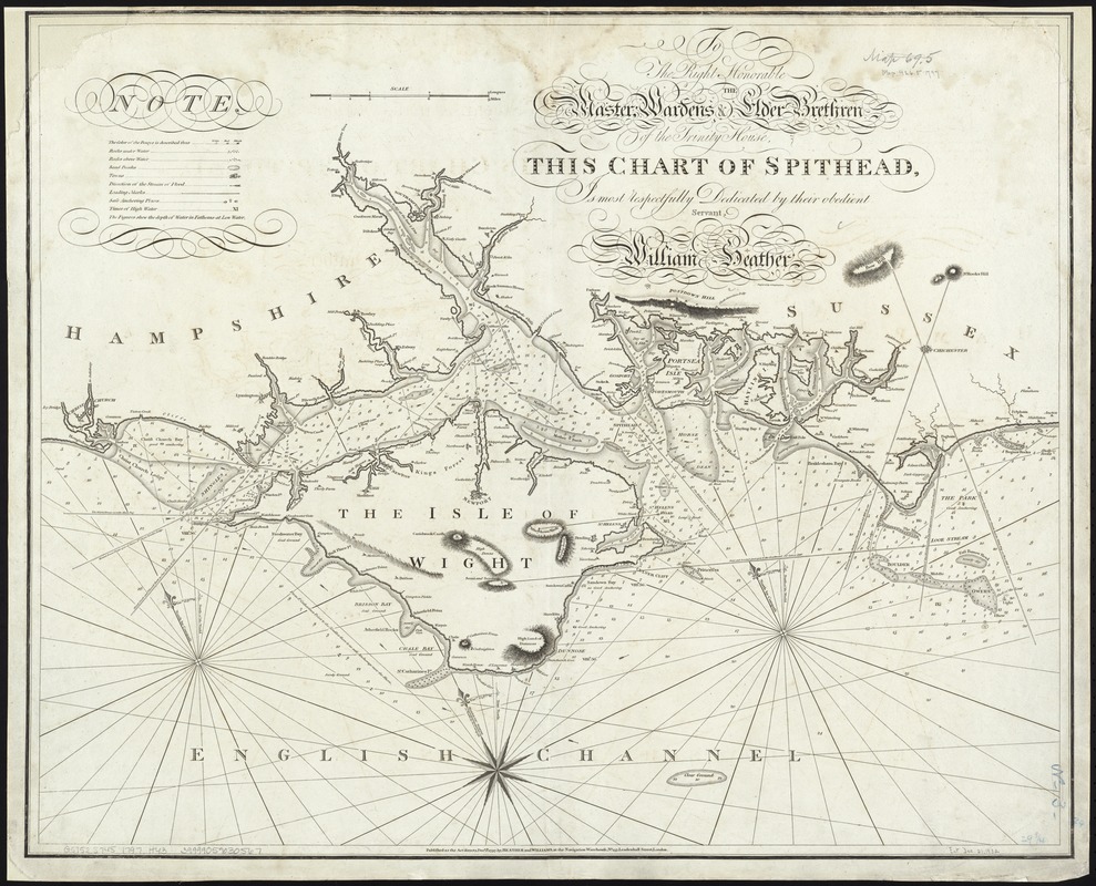
To the right honorable the master, wardens & elder brethren of the Trinity House, this chart of Spithead is ... dedicated
To the right honorable the master, wardens & elder brethren of the Trinity House, this chart of Spithead is ... dedicated
×
Item Information
Title:
To the right honorable the master, wardens & elder brethren of the Trinity House, this chart of Spithead is ... dedicated
Creator:
Heather, William, 1764-1812
Name on Item:
by ... William Heather ; Engraved by J. Stephenson.
Date:
1797
Format:
Maps/Atlases
Location:
Boston Public Library
Norman B. Leventhal Map Center
Collection (local):
Norman B. Leventhal Map Center Collection
Subjects:
Spithead Channel (England)--Maps--Early works to 1800
Places:
England
>
Hampshire (county)
>
Spithead
(channel)
Extent:
1 chart ; 64 x 78 cm.
Permalink:
https://ark.digitalcommonwealth.org/ark:/50959/kk91fr360
Terms of Use:
No known copyright restrictions.
No known restrictions on use.
Publisher:
London : Heather and Williams
Scale:
Scale [ca. 1:110 000]. Scale 9 miles [=131mm].
Language:
English
Notes:
Relief shown by hachures. Depths shown by soundings.
Cataloging, conservation, and digitization made possible in part by The National Endowment for the Humanities: Exploring the human endeavor.
Identifier:
06_01_007276
Call #:
G5752.S745 1797 .H43
Barcode:
39999059030567
show more...
View MODS XML
More Like This
The 100th anniversary map of Abraham Lincoln's visit to ...
1630 shoreline
1879. Progress map of the U.S. Geographical Surveys west of the ...
1903 Map of Salem and surrounding places
Find More Like This >>
Tools
Share
Facebook
Pinterest
X
Reddit
Tumblr
Email
Copy link
Add to Folder
Questions/Comments
Cite This Item
IIIF Manifest
Downloads
Primary (full resolution, uncompressed)
(TIF, 228 MB)
Large (full resolution)
(JPEG, 19.1 MB)
Medium
(JPEG, 305 KB)