Skip to search
Skip to main content
Digital Commonwealth
Sign Up / Log In
Search for
Search
Search
Search
Basic
Advanced
Explore
Map
Collections
Institutions
Formats
For Educators
Primary Source Sets
Lesson Plans
Using Primary Sources
Searching Digital Commonwealth
For Institutions
Join Digital Commonwealth
Conferences, Trainings, & Events
How to Contribute Collections
Digitization Services
Board & Committees
Frequently Asked Questions
About
About Digital Commonwealth
News & Announcements
Copyright & Terms of Use
Harmful Content Statement
Partners
API
Contact Us
Boston Public Library
Norman B. Leventhal Map Center Collection
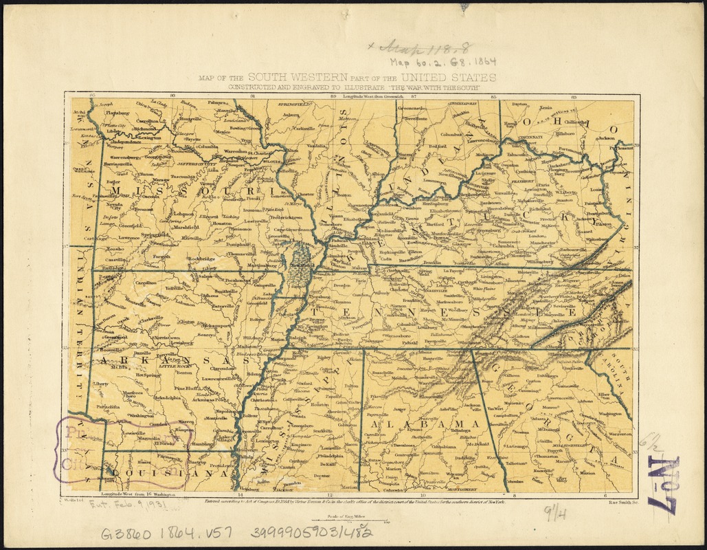
Map of the south western part of the United States : constructed and engraved to illustrate "The War with the South"
Map of the south western part of the United States
×
Item Information
Title:
Map of the south western part of the United States : constructed and engraved to illustrate "The War with the South"
Title (alt.):
Map of the southwestern part of the United States
Creator:
Virtue, Yorston & Co
Name on Item:
J. Wells del. ; Rae Smith sc.
Date:
1864
Format:
Maps/Atlases
Location:
Boston Public Library
Norman B. Leventhal Map Center
Collection (local):
Norman B. Leventhal Map Center Collection
Subjects:
Southern States--Maps
Places:
Southern United States
(area)
Extent:
1 map : col. ; 17 x 24 cm.
Permalink:
https://ark.digitalcommonwealth.org/ark:/50959/kk91fs544
Terms of Use:
No known copyright restrictions.
No known restrictions on use.
Publisher:
[New York?] : Virtue Yorston & Co.
Scale:
Scale [ca. 1:5,300,000]
Language:
English
Notes:
Relief shown by hachures.
Shows Missouri, Arkansas, Kentucky, Tennessee, and portions of Kansas, Texas, Illinois, Indiana, Ohio, Virginia, Louisiana, Mississippi, Alabama, Georgia, North Carolina, and South Carolina.
Identifier:
06_01_007446
Call #:
G3860 1864 .V57
Barcode:
39999059031482
show more...
View MODS XML
More Like This
Colton's rail road and county map of the Southern States ...
The cotton kingdom
Johnson's new rail road & county copper plate map of the Southern ...
Lloyd's map of the Southern States, showing all the railroads, ...
Find More Like This >>
Tools
Share
Facebook
Pinterest
X
Reddit
Tumblr
Email
Copy link
Add to Folder
Questions/Comments
Cite This Item
IIIF Manifest
Downloads
Primary (full resolution, uncompressed)
(TIF, 109 MB)
Large (full resolution)
(JPEG, 9.13 MB)
Medium
(JPEG, 354 KB)