Skip to search
Skip to main content
Digital Commonwealth
Sign Up / Log In
Search for
Search
Search
Search
Basic
Advanced
Explore
Map
Collections
Institutions
Formats
For Educators
Primary Source Sets
Lesson Plans
Using Primary Sources
Searching Digital Commonwealth
For Institutions
Join Digital Commonwealth
Conferences, Trainings, & Events
How to Contribute Collections
Digitization Services
Board & Committees
Frequently Asked Questions
About
About Digital Commonwealth
News & Announcements
Copyright & Terms of Use
Harmful Content Statement
Partners
API
Contact Us
Boston Public Library
Norman B. Leventhal Map Center Collection
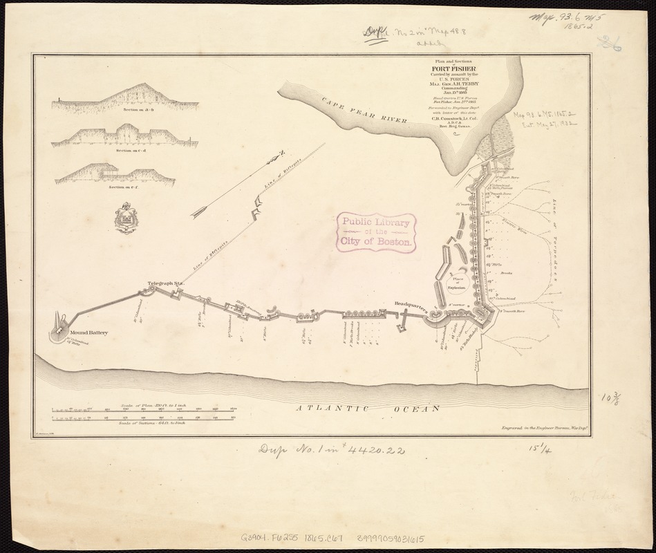
Plan and sections of Fort Fisher, carried by assault by the U.S. forces, Maj. Gen. A.H. Terry commanding, Jan. 15th, 1865
Plan and sections of Fort Fisher, carried by assault by the U.S. forces, Maj. Gen. A.H. Terry commanding, Jan. 15th, 1865
×
Item Information
Title:
Plan and sections of Fort Fisher, carried by assault by the U.S. forces, Maj. Gen. A.H. Terry commanding, Jan. 15th, 1865
Creator:
Comstock, C. B. (Cyrus Ballou), 1831-1910
Date:
[1865?]
Format:
Maps/Atlases
Location:
Boston Public Library
Norman B. Leventhal Map Center
Collection (local):
Norman B. Leventhal Map Center Collection
Subjects:
Fort Fisher (N.C. : Fort)--History--19th century--Maps
Terry, Alfred Howe, 1827-1890
Places:
New Hanover (county)
>
Fort Fisher
(historic site)
Extent:
1 map ; 27 x 39 cm.
Permalink:
https://ark.digitalcommonwealth.org/ark:/50959/kk91fs70h
Terms of Use:
No known copyright restrictions.
No known restrictions on use.
Publisher:
Washington, D.C.? : U.S. War Dept., Engineer Bureau
Scale:
Scale [1:3,840]. 320 ft. to 1 in.
Language:
English
Notes:
Head qurtrs., U.S. forces, Fort Fisher, Jan. 27th, 1865, forwarded to Engineer Dept. with letter of this date, C.B. Comstock, Lt. Col., A.D.C. & Brvt. Brig. Gen. &&.
Relief shown by hachures.
Includes 3 cross sections.
Identifier:
06_01_007459
Call #:
G3904.F62S5 1865 .C67
Barcode:
39999059031615
39999059032795
39999059032811
LCCN:
86690228
show more...
View MODS XML
More Like This
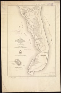
Sketch of vicinity of Fort Fisher
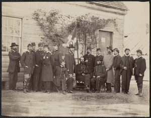
General Alfred H. Terry and staff, Hatcher's Farm Virginia
The 100th anniversary map of Abraham Lincoln's visit to ...
1630 shoreline
Find More Like This >>
Tools
Share
Facebook
Pinterest
X
Reddit
Tumblr
Email
Copy link
Add to Folder
Questions/Comments
Cite This Item
IIIF Manifest
Downloads
Primary (full resolution, uncompressed)
(TIF, 210 MB)
Large (full resolution)
(JPEG, 17.6 MB)
Medium
(JPEG, 170 KB)