Skip to search
Skip to main content
Digital Commonwealth
Sign Up / Log In
Search for
Search
Search
Search
Basic
Advanced
Explore
Map
Collections
Institutions
Formats
For Educators
Primary Source Sets
Lesson Plans
Using Primary Sources
Searching Digital Commonwealth
For Institutions
Join Digital Commonwealth
Conferences, Trainings, & Events
How to Contribute Collections
Digitization Services
Board & Committees
Frequently Asked Questions
About
About Digital Commonwealth
News & Announcements
Copyright & Terms of Use
Harmful Content Statement
Partners
API
Contact Us
Boston Public Library
Norman B. Leventhal Map Center Collection
/
Urban Maps (Collection of Distinction)
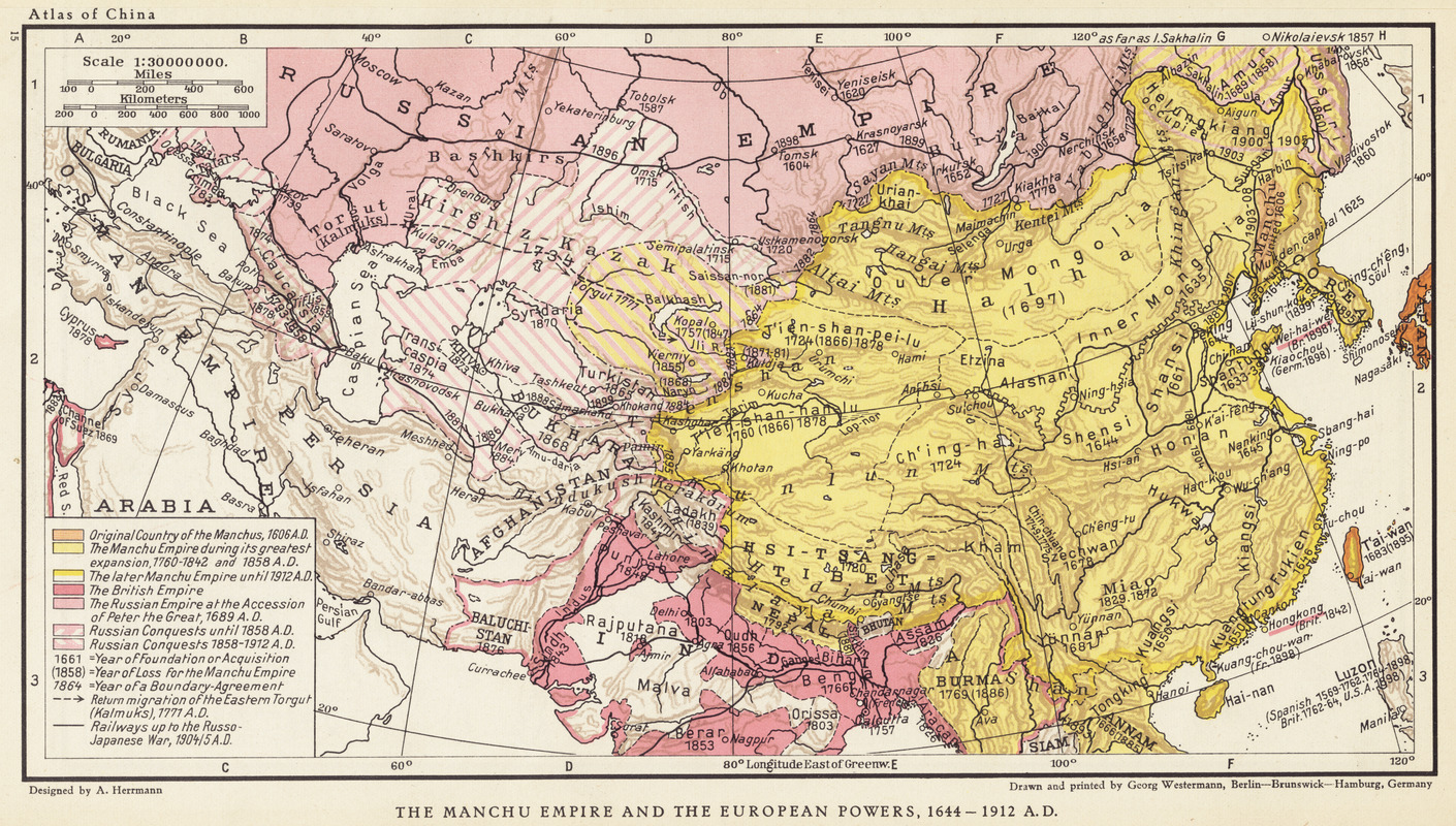
The Manchu Empire and the European powers, 1644-1912, A.D.
The Manchu Empire and the European powers, 1644-1912, A.D.
×
Item Information
Title:
The Manchu Empire and the European powers, 1644-1912, A.D.
Cartographer:
Herrmann, Albert, 1886-1945
Date:
1935
Format:
Maps/Atlases
Location:
Boston Public Library
Norman B. Leventhal Map Center
Collection (local):
Norman B. Leventhal Map Center Collection
Subjects:
Manchuria (China)--Historical geography--Maps
Places:
Manchuria
(area)
Extent:
1 map : color ; 16 x 30 cm
Permalink:
https://ark.digitalcommonwealth.org/ark:/50959/q524n195v
Terms of Use:
Copyright (c) Harvard University Press.
All rights reserved.
Publisher:
Cambridge [Mass.] : Harvard University Press
Scale:
Scale 1:30,000,000
Language:
English
Notes:
From Historical and commercial atlas of China.
Identifier:
06_01_004265
Call #:
G2305 .H4 1935
Barcode:
39999059005395
show more...
View MODS XML
More Like This
The 100th anniversary map of Abraham Lincoln's visit to ...
1630 shoreline
1879. Progress map of the U.S. Geographical Surveys west of the ...
1903 Map of Salem and surrounding places
Find More Like This >>
Tools
Share
Facebook
Pinterest
X
Reddit
Tumblr
Email
Copy link
Add to Folder
Questions/Comments
Cite This Item
IIIF Manifest