Skip to search
Skip to main content
Digital Commonwealth
Sign Up / Log In
Search for
Search
Search
Search
Basic
Advanced
Explore
Map
Collections
Institutions
Formats
For Educators
Primary Source Sets
Lesson Plans
Using Primary Sources
Searching Digital Commonwealth
For Institutions
Join Digital Commonwealth
Conferences, Trainings, & Events
How to Contribute Collections
Digitization Services
Board & Committees
Frequently Asked Questions
About
About Digital Commonwealth
News & Announcements
Copyright & Terms of Use
Harmful Content Statement
Partners
API
Contact Us
Phillips Academy
Campus Maps from Phillips Academy Archives and Special Collections
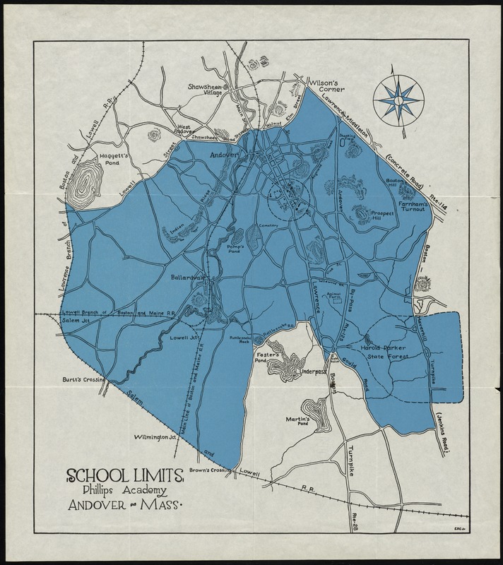
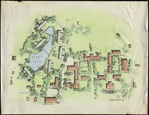
School limits, Phillips Academy, Andover, Mass.
School limits, Phillips Academy, Andover, Mass.
×
Item Information
Title:
School limits, Phillips Academy, Andover, Mass.
Creator:
ESC Jr.
Contributor:
Bartlett, L. L.
Name on Item:
ESC Jr.
Date:
[1955?–1966?]
Format:
Maps/Atlases
Location:
Phillips Academy
Archives and Special Collections
Collection (local):
Phillips Academy Archives and Special Collections
Subjects:
Phillips Academy
Places:
Essex (county)
>
Andover
Extent:
1 map : col. ; 39 x 34 cm.
Permalink:
https://ark.digitalcommonwealth.org/ark:/50959/r781wp65n
Terms of Use:
Rights status not evaluated.
Contact host institution for more information.
Publisher:
[S.l] : [s.n.]
Scale:
Scale [ca 1:34,000]
Language:
English
Notes:
Covers Andover and parts of surrounding towns.
Relief shown by hachures.
Oriented with north towards the upper left.
Dashed circle indicates main campus of Phillips Academy.
Identifier:
1508
show more...
View MODS XML
More Like This
Phillips Academy, Andover, Mass. : plan for development of lands ...
Phillips Academy, Andover, Massachusetts
Phillips Academy, Andover, Massachusetts, map of property
Plan for the area around Rabbit Pond
Find More Like This >>
Tools
Share
Facebook
Pinterest
X
Reddit
Tumblr
Email
Copy link
Add to Folder
Questions/Comments
Cite This Item
IIIF Manifest