Skip to search
Skip to main content
Digital Commonwealth
Sign Up / Log In
Search for
Search
Search
Search
Basic
Advanced
Explore
Map
Collections
Institutions
Formats
For Educators
Primary Source Sets
Lesson Plans
Using Primary Sources
Searching Digital Commonwealth
For Institutions
Join Digital Commonwealth
Conferences, Trainings, & Events
How to Contribute Collections
Digitization Services
Board & Committees
Frequently Asked Questions
About
About Digital Commonwealth
News & Announcements
Copyright & Terms of Use
Harmful Content Statement
Partners
API
Contact Us
State Library of Massachusetts
Massachusetts Real Estate Atlases
Atlas of Berkshire County, Massachusetts
Read online
Item Information
Title:
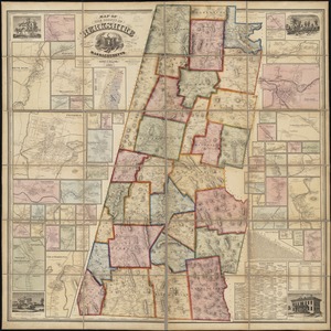
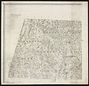
Atlas of Berkshire County, Massachusetts
Publisher:
Barnes & Farnham
Date:
1904
Format:
Maps/Atlases
Location:
State Library of Massachusetts
Collection (local):
Massachusetts Real Estate Atlases
Subjects:
Berkshire County (Mass.)--Maps
Real property--Massachusetts--Berkshire County--Maps
Landowners--Massachusetts--Berkshire County--Maps
Places:
Berkshire (county)
Extent:
1 atlas (62, that is, 124 leaves) : color maps ; 56 cm
Permalink:
https://ark.digitalcommonwealth.org/ark:/50959/w6636t58r
Terms of Use:
Prior written permission required to use any image from the digital collections of the State Library of Massachusetts.
Contact host institution for more information.
Publisher:
Pittsfield, Mass. : Barnes & Farnham
Language:
English
Referenced by:
Catalog record
Identifier:
Atlas_Mass_Berkshire_Co_1904
show more...
View MODS XML
More Like This
County atlas of Berkshire Massachusetts
Map of the county of Berkshire, Massachusetts : based upon the ...
Atlas of Berkshire County, Massachusetts
Map and profile showing by the red line the proposed extension of ...
Find More Like This >>
Tools
Share
Facebook
Pinterest
X
Reddit
Tumblr
Email
Copy link
Add to Folder
Questions/Comments
Cite This Item
IIIF Manifest