Skip to search
Skip to main content
Digital Commonwealth
Sign Up / Log In
Search for
Search
Search
Search
Basic
Advanced
Explore
Map
Collections
Institutions
Formats
For Educators
Primary Source Sets
Lesson Plans
Using Primary Sources
Searching Digital Commonwealth
For Institutions
Join Digital Commonwealth
Conferences, Trainings, & Events
How to Contribute Collections
Digitization Services
Board & Committees
Frequently Asked Questions
About
About Digital Commonwealth
News & Announcements
Copyright & Terms of Use
Harmful Content Statement
Partners
API
Contact Us
Boston Public Library
Norman B. Leventhal Map Center Collection
/
American Revolutionary War-Era Maps (Collection of Distinction)
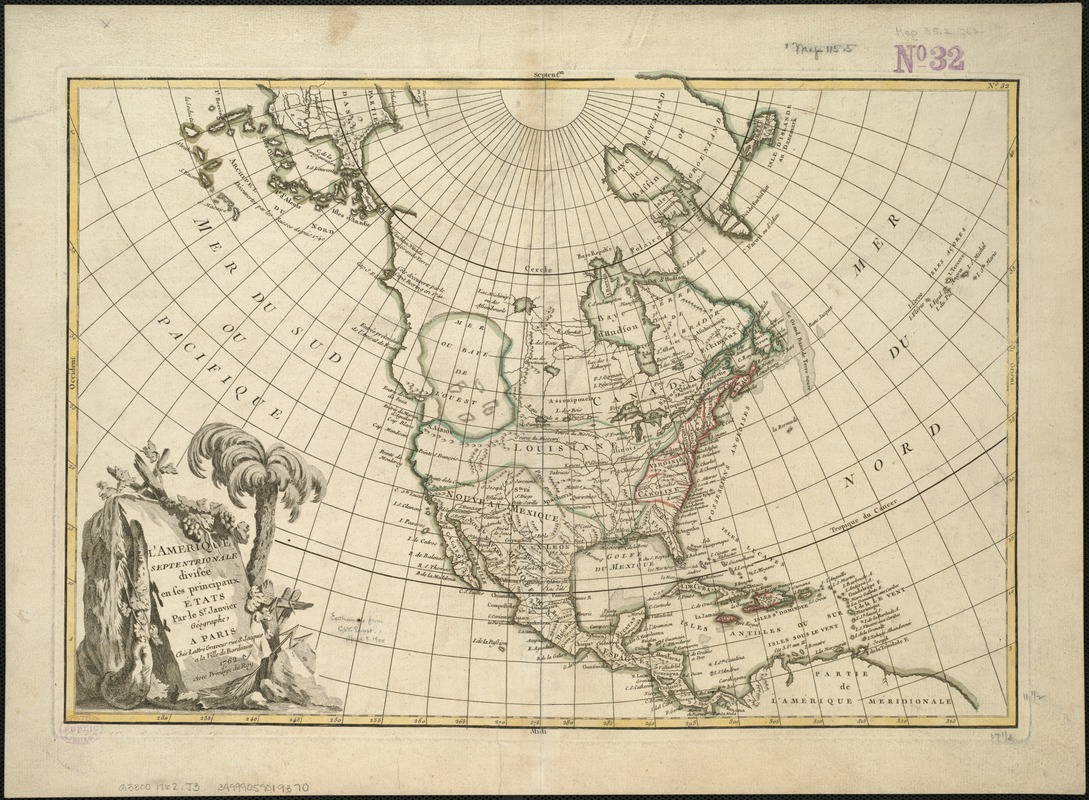
L'Amérique Septentrionale divisée en ses principaux états
LAmérique Septentrionale divisée en ses principaux états
×
Item Information
Title:
L'Amérique Septentrionale divisée en ses principaux états
Creator:
Janvier, Jean Denis.
Name on Item:
par le Sr. Janvier géographe ; Morillier, invenit ; Berthault, sculpcit.
Date:
1762
Format:
Maps/Atlases
Location:
Boston Public Library
Norman B. Leventhal Map Center
Collection (local):
Norman B. Leventhal Map Center Collection
Subjects:
North America--Maps--Early works to 1800
Places:
North America
(area)
Extent:
1 map : col. ; 31 x 45 cm.
Permalink:
https://ark.digitalcommonwealth.org/ark:/50959/w9505r67t
Terms of Use:
No known copyright restrictions.
No known restrictions on use.
Publisher:
A Paris : Chez Lattré graveur rue St. Jacques a la Ville de Bordeaux
Scale:
Scale 1:22,500,000.
Language:
French
Notes:
Relief shown pictorially.
Cartouche designed by: Morillier.
Cartouche engraved by: Berthault.
In border at upper right: 32.
Appears in Atlas moderne, ou, Collection de cartes sur toutes les parties du globe terrestre. Paris, 1762.
Identifier:
06_01_006072
Call #:
G3300 1762 .J3
Barcode:
39999059019370
show more...
View MODS XML
More Like This
An accurate map of North America : describing and distinguishing ...
An accurate map of North America : describing and distinguishing ...
An accurate map of North America : describing and distinguishing ...
America : with those known parts in that unknowne worlde both ...
Find More Like This >>
Tools
Share
Facebook
Pinterest
X
Reddit
Tumblr
Email
Copy link
Add to Folder
Questions/Comments
Cite This Item
IIIF Manifest
Downloads
Primary (full resolution, uncompressed)
(TIF, 159 MB)
Large (full resolution)
(JPEG, 13.3 MB)
Medium
(JPEG, 371 KB)