Skip to search
Skip to main content
Digital Commonwealth
Sign Up / Log In
Search for
Search
Search
Search
Basic
Advanced
Explore
Map
Collections
Institutions
Formats
For Educators
Primary Source Sets
Lesson Plans
Using Primary Sources
Searching Digital Commonwealth
For Institutions
Join Digital Commonwealth
Conferences, Trainings, & Events
How to Contribute Collections
Digitization Services
Board & Committees
Frequently Asked Questions
About
About Digital Commonwealth
News & Announcements
Copyright & Terms of Use
Harmful Content Statement
Partners
API
Contact Us
Boston Public Library
Norman B. Leventhal Map Center Collection
/
American Revolutionary War-Era Maps (Collection of Distinction)
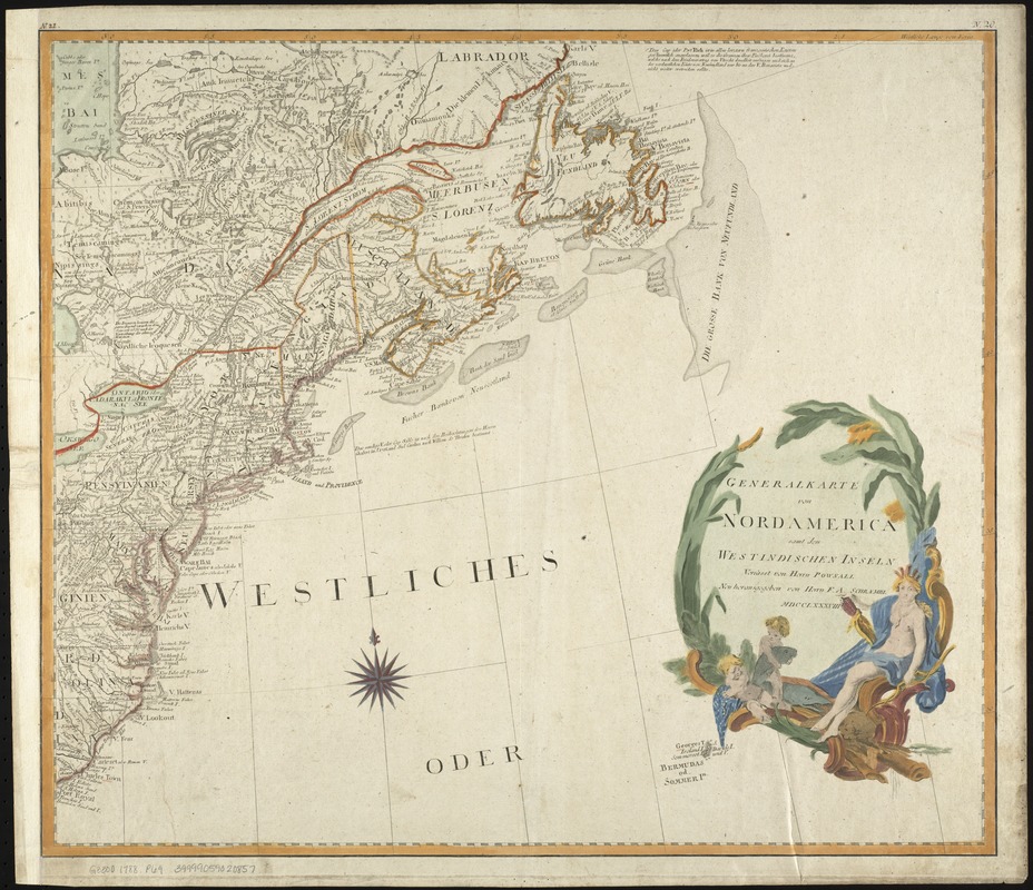
Generalkarte von Nord America samt den Westindischen inseln
Generalkarte von Nord America samt den Westindischen inseln
×
Item Information
Title:
Generalkarte von Nord America samt den Westindischen inseln
Inset title :
Specialkarte von der Baffin und Hudsons Bai
Inset title :
P. Eusebius Franz Kino aus der G.J
Creator:
Pownall, Thomas, 1722-1805
Name on Item:
verfasst von Herrn Pownall.
Date:
1788
Format:
Maps/Atlases
Location:
Boston Public Library
Norman B. Leventhal Map Center
Collection (local):
Norman B. Leventhal Map Center Collection
Subjects:
North America--Maps--Early works to 1800
Places:
North America
(area)
Extent:
1 map on 2 sheets : outline col. ; 101.8 x 115.7 cm.
Permalink:
https://ark.digitalcommonwealth.org/ark:/50959/w9505s78j
Terms of Use:
No known copyright restrictions.
No known restrictions on use.
Publisher:
[Vienna] : F.A. Schraembl
Scale:
Scale 1:5,150,000.
Language:
German
Notes:
Relief shown pictorially.
Engraved by: J. Stenger in Wien.
Cataloging, conservation, and digitization made possible in part by The National Endowment for the Humanities: Exploring the human endeavor.
Identifier:
06_01_008024
Call #:
G3300 1788 .P68
Barcode:
39999059020857
show more...
View MODS XML
More Like This
An accurate map of North America : describing and distinguishing ...
An accurate map of North America : describing and distinguishing ...
An accurate map of North America : describing and distinguishing ...
America : with those known parts in that unknowne worlde both ...
Find More Like This >>
Tools
Share
Facebook
Pinterest
X
Reddit
Tumblr
Email
Copy link
Add to Folder
Questions/Comments
Cite This Item
IIIF Manifest
Downloads
Primary (full resolution, uncompressed)
(TIF, 137 MB)
Large (full resolution)
(JPEG, 11.5 MB)
Medium
(JPEG, 282 KB)