Skip to search
Skip to main content
Digital Commonwealth
Sign Up / Log In
Search for
Search
Search
Search
Basic
Advanced
Explore
Map
Collections
Institutions
Formats
For Educators
Primary Source Sets
Lesson Plans
Using Primary Sources
Searching Digital Commonwealth
For Institutions
Join Digital Commonwealth
Conferences, Trainings, & Events
How to Contribute Collections
Digitization Services
Board & Committees
Frequently Asked Questions
About
About Digital Commonwealth
News & Announcements
Copyright & Terms of Use
Harmful Content Statement
Partners
API
Contact Us
Boston Public Library
Norman B. Leventhal Map Center Collection
/
American Revolutionary War-Era Maps (Collection of Distinction)
/
Maritime Charts and Atlases (Collection of Distinction)
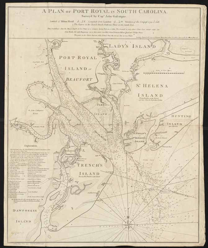
A plan of Port Royal in South Carolina
A plan of Port Royal in South Carolina
×
Item Information
Title:
A plan of Port Royal in South Carolina
Creator:
Gascoigne, John.
Name on Item:
survey'd by Capn. John Gascoigne.
Date:
1776
Format:
Maps/Atlases
Location:
Boston Public Library
Norman B. Leventhal Map Center
Collection (local):
Norman B. Leventhal Map Center Collection
Subjects:
Nautical charts--South Carolina--Port Royal Sound
Port Royal Sound (S.C.)--Maps--Early works to 1800
Places:
Beaufort (county)
>
Port Royal Sound
(bay)
Extent:
1 map ; 62 x 58 cm.
Permalink:
https://ark.digitalcommonwealth.org/ark:/50959/wd3765002
Terms of Use:
No known copyright restrictions.
No known restrictions on use.
Publisher:
London : printed for R. Sayer & J. Bennett ...
Scale:
Scale 1:63,360.
Language:
English
Notes:
Depths shown by soundings.
"Latitude of Hilton Head ... Longitude from London ... variation of the compass ..."
"These soundings shew the exact depth at low water on a common spring tide in a calm ..."
Identifier:
06_01_002541
Call #:
G3912.P62 1776 .G3
Barcode:
39999058995430
show more...
View MODS XML
More Like This
A plan of Port Royal harbour in Carolina with the proposed forts, ...
Port Royal in South Carolina : taken from surveys deposited at the ...
The 100th anniversary map of Abraham Lincoln's visit to ...
1630 shoreline
Find More Like This >>
Tools
Share
Facebook
Pinterest
X
Reddit
Tumblr
Email
Copy link
Add to Folder
Questions/Comments
Cite This Item
IIIF Manifest
Downloads
Primary (full resolution, uncompressed)
(TIF, 174 MB)
Large (full resolution)
(JPEG, 14.6 MB)
Medium
(JPEG, 215 KB)