Skip to search
Skip to main content
Digital Commonwealth
Sign Up / Log In
Search for
Search
Search
Search
Basic
Advanced
Explore
Map
Collections
Institutions
Formats
For Educators
Primary Source Sets
Lesson Plans
Using Primary Sources
Searching Digital Commonwealth
For Institutions
Join Digital Commonwealth
Conferences, Trainings, & Events
How to Contribute Collections
Digitization Services
Board & Committees
Frequently Asked Questions
About
About Digital Commonwealth
News & Announcements
Copyright & Terms of Use
Harmful Content Statement
Partners
API
Contact Us
Boston Public Library
Norman B. Leventhal Map Center Collection
/
American Revolutionary War-Era Maps (Collection of Distinction)
Recens edita totius Novi Belgii, in America Septentrionali siti
Recens edita totius Novi Belgii, in America Septentrionali siti
×
Item Information
Title:
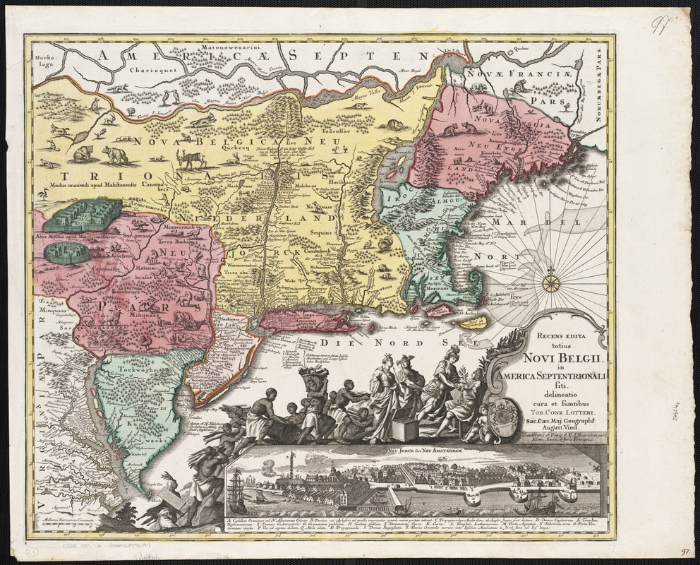
Recens edita totius Novi Belgii, in America Septentrionali siti
Creator:
Lotter, Tobias Conrad, 1717-1777
Name on Item:
delineatio cura et sumptibus Tob. Conr. Lotter Sac. Caes. Maj. Geographi August. Vind.
Date:
[1757–1777]
Format:
Maps/Atlases
Location:
Boston Public Library
Norman B. Leventhal Map Center
Collection (local):
Norman B. Leventhal Map Center Collection
Subjects:
East (U.S.)--Maps--Early works to 1800
Places:
Eastern United States
(area)
Extent:
1 map : col. ; 48 x 56 cm.
Permalink:
https://ark.digitalcommonwealth.org/ark:/50959/wd376514d
Terms of Use:
No known copyright restrictions.
No known restrictions on use.
Publisher:
Augsburg : Lotter
Scale:
Scale not given.
Language:
Latin
German
Notes:
Relief shown pictorially.
Includes ill. and inset of Neu Jorck sive Neu Amsterdam.
"Cum Gratia et Privil. S.R.I. Vicariat in part, Rheni, Sveviae, et Juris Franconici."
Notes (date):
This date is inferred.
Identifier:
06_01_002548
Call #:
G3715 1757 .L6
Barcode:
39999058995497
show more...
View MODS XML
More Like This
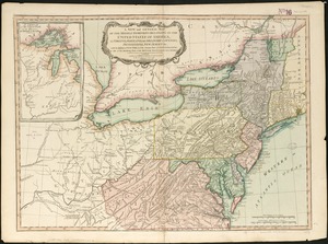
Map of the United States in North America : with the British, ...
A new and general map of the middle dominions belonging to the ...
The 100th anniversary map of Abraham Lincoln's visit to ...
1630 shoreline
Find More Like This >>
Tools
Share
Facebook
Pinterest
X
Reddit
Tumblr
Email
Copy link
Add to Folder
Questions/Comments
Cite This Item
IIIF Manifest
Downloads
Primary (full resolution, uncompressed)
(TIF, 198 MB)
Large (full resolution)
(JPEG, 16.7 MB)
Medium
(JPEG, 402 KB)