Skip to search
Skip to main content
Digital Commonwealth
Sign Up / Log In
Search for
Search
Search
Search
Basic
Advanced
Explore
Map
Collections
Institutions
Formats
For Educators
Primary Source Sets
Lesson Plans
Using Primary Sources
Searching Digital Commonwealth
For Institutions
Join Digital Commonwealth
Conferences, Trainings, & Events
How to Contribute Collections
Digitization Services
Board & Committees
Frequently Asked Questions
About
About Digital Commonwealth
News & Announcements
Copyright & Terms of Use
Harmful Content Statement
Partners
API
Contact Us
Boston Public Library
Norman B. Leventhal Map Center Collection
/
Maritime Charts and Atlases (Collection of Distinction)
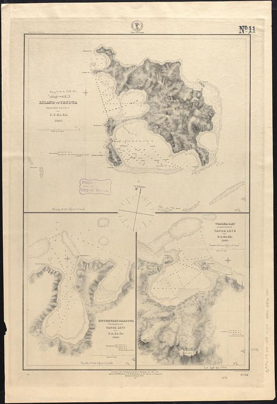
Island of Yendua, Feejee Group ; Nucumurry Harbour, west end of Vanua Levu ; Wailea Bay, north side of Vanua Levu
Island of Yendua, Feejee Group ; Nucumurry Harbour, west end of Vanua Levu ; Wailea Bay, north side of Vanua Levu
×
Item Information
Title:
Island of Yendua, Feejee Group ; Nucumurry Harbour, west end of Vanua Levu ; Wailea Bay, north side of Vanua Levu
Issuing body:
United States. Hydrographic Office
Surveyor:
United States Exploring Expedition (1838-1842)
Name on Item:
by U.S. Ex. Ex. 1840
Date:
[1888]
Format:
Maps/Atlases
Genre:
Nautical charts
Location:
Boston Public Library
Norman B. Leventhal Map Center
Collection (local):
Norman B. Leventhal Map Center Collection
Subjects:
Yandua Island (Fiji)--Maps
Vanua Levu (Fiji)--Maps
Nautical charts--Fiji--Vanua Levu
Nautical charts--Fiji--Yandua Island
Places:
Fiji
>
Bua
(province)
>
Yadua Island
(island)
Fiji
>
Nadroga and Navosa
(province)
>
Vanua Levu Island
(island)
Extent:
3 maps on 1 sheet ; 59 x 39 cm
Permalink:
https://ark.digitalcommonwealth.org/ark:/50959/z029rm351
Terms of Use:
No known copyright restrictions.
No known restrictions on use.
Publisher:
Washington, D.C. : Hydrographic Office
Edition:
Edition of January 1888
Scale:
Scale approximately 1:24,500
Scale approximately 1:24,700
Scale approximately 1:24,700
Language:
English
Table of Contents:
Island of Yendua
Nucumurry Harbour
Wailea Bay
Notes:
Relief shown by hachures. Depths shown by soundings and pictorially.
Scale bar on map of Yendua incorrect. Scale bar covers 1 nautical mile, not 2 as labeled.
Notes (date):
This date is inferred.
Identifier:
06_01_017512
Call #:
G9096.P5 svar .U55 no. 114
Barcode:
39999085960241
show more...
View MODS XML
More Like This
Island of Yendua, Feejee Group ; Nucumurry Harbour, west end of ...
Channel on the north side of Vanua Levu from Aramula Passage to ...
Channel on the north side of Vanua Levu from Aramula Passage to ...
Harbour of Muthuata, north side of Vanua Levu ; Tibethe & Vicuna ...
Find More Like This >>
Tools
Share
Facebook
Pinterest
X
Reddit
Tumblr
Email
Copy link
Add to Folder
Questions/Comments
Cite This Item
IIIF Manifest
Downloads
Primary (full resolution, uncompressed)
(TIF, 126 MB)
Large (full resolution)
(JPEG, 10.6 MB)
Medium
(JPEG, 75 KB)