Skip to search
Skip to main content
Digital Commonwealth
Sign Up / Log In
Search for
Search
Search
Search
Basic
Advanced
Explore
Map
Collections
Institutions
Formats
For Educators
Primary Source Sets
Lesson Plans
Using Primary Sources
Searching Digital Commonwealth
For Institutions
Join Digital Commonwealth
Conferences, Trainings, & Events
How to Contribute Collections
Digitization Services
Board & Committees
Frequently Asked Questions
About
About Digital Commonwealth
News & Announcements
Copyright & Terms of Use
Harmful Content Statement
Partners
API
Contact Us
American Antiquarian Society
American Revolutionary War-Era Maps (Collection of Distinction)
/
American Antiquarian Society Collection
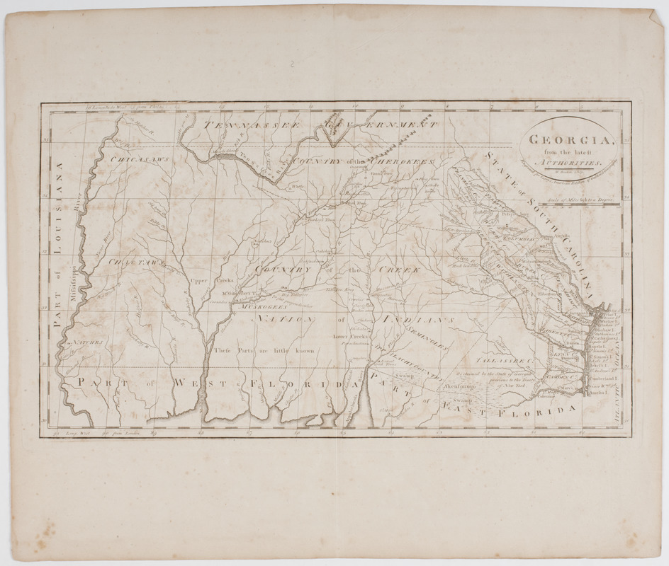
Georgia from the latest authorities
Georgia from the latest authorities
×
Item Information
Title:
Georgia from the latest authorities
Title (uniform):
General atlas for Carey's edition of Guthrie's geography improved
Description:
Subject: Map of the state of Georgia showing different Native American lands within the state.
Engraver:
Barker, W. (William), active 1795-1803
Publisher:
M. Carey (Firm)
Name on Item:
W. Barker sculpt.
Date:
[1795]
Format:
Maps/Atlases
Location:
American Antiquarian Society
Collection (local):
American Antiquarian Society Collection
Subjects:
Georgia--Maps
Places:
Georgia
Extent:
1 map : engraving ; 23 x 41 cm., on sheet 38 x 45 cm.
Permalink:
https://ark.digitalcommonwealth.org/ark:/50959/z603vg21r
Terms of Use:
Public Domain/No known restrictions on use. Contact host institution to download image.
Contact host institution for more information.
Publisher:
Philadelphia : Mathew Carey
Scale:
Scale [ca. 1:3,000,000]
Language:
English
Referenced by:
http://catalog.mwa.org/vwebv/holdingsInfo?bibId=476145
Notes:
Relief shown pictorially.
From General atlas for Carey's edition of Guthrie's geography improved, Philadelphia, 1795 (Bristol B9043; Shipton & Mooney 47370).
"Engraved for Carey's American edition of Guthrie's geography."
State I.
Notes (date):
This date is inferred.
show more...
View MODS XML
More Like This
Carte de la Caroline et Georgie. : Pour servir à l'Histoire ...
Carte de la Caroline et Georgie. : Pour servir à l'Histoire ...
A new & accurate map of the provinces of North & South Carolina ...
A New and accurate map of the chief parts of South Carolina, and ...
Find More Like This >>
Tools
Share
Facebook
Pinterest
X
Reddit
Tumblr
Email
Copy link
Add to Folder
Questions/Comments
Cite This Item
IIIF Manifest