Skip to search
Skip to main content
Digital Commonwealth
Sign Up / Log In
Search for
Search
Search
Search
Basic
Advanced
Explore
Map
Collections
Institutions
Formats
For Educators
Primary Source Sets
Lesson Plans
Using Primary Sources
Searching Digital Commonwealth
For Institutions
Join Digital Commonwealth
Conferences, Trainings, & Events
How to Contribute Collections
Digitization Services
Board & Committees
Frequently Asked Questions
About
About Digital Commonwealth
News & Announcements
Copyright & Terms of Use
Harmful Content Statement
Partners
API
Contact Us
Boston Public Library
Norman B. Leventhal Map Center Collection
/
Boston and New England Maps (Collection of Distinction)
/
Maritime Charts and Atlases (Collection of Distinction)
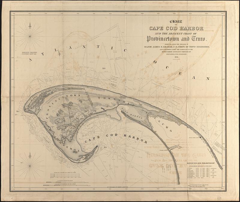
Chart of Cape Cod Harbor and the adjacent coast of Provincetown and Truro
Chart of Cape Cod Harbor and the adjacent coast of Provincetown and Truro
×
Item Information
Title:
Chart of Cape Cod Harbor and the adjacent coast of Provincetown and Truro
Cartographer:
Lewis, Winslow, 1770-1850
Cartographer:
Graham, J. D. (James Duncan), 1799-1865
Publisher:
Boston Marine Insurance Company
Name on Item:
reduced from the original of James D. Graham, U.S. Corps of Topol. Engineers, and published under the patronage of the Boston Marine Insurance Companies by I.W.P. Lewis ; surveyed and projected by J.D. Graham, Major U.S. Top. Engs.
Date:
1841
Format:
Maps/Atlases
Genre:
Nautical charts
Location:
Boston Public Library
Norman B. Leventhal Map Center
Collection (local):
Norman B. Leventhal Map Center Collection
Subjects:
Provincetown (Mass.)--Maps
Truro (Mass.)--Maps
Harbors--Massachusetts--Provincetown--Maps
Nautical charts--Massachusetts--Cape Cod
Places:
Barnstable (county)
>
Provincetown
Barnstable (county)
>
Truro
Extent:
1 map ; 68 x 83 cm
Permalink:
https://ark.digitalcommonwealth.org/ark:/50959/zw131n745
Terms of Use:
No known copyright restrictions.
No known restrictions on use.
Publisher:
[United States] : I.W.P. Lewis
Scale:
Scale 1:21,120. 3 inches to 1 mile
Language:
English
Notes:
Relief shown by hachures and spot heights. Depths shown by contours and soundings.
Identifier:
06_01_017151
Call #:
G3762.C35P5 1841 .L49
Barcode:
39999085955761
show more...
View MODS XML
More Like This
Comparative map of Cape Cod Harbor showing physical changes ...
Provincetown Harbor
Atlas of the boundaries of the towns of Barnstable, Brewster, ...
Provincetown Harbor, Massachusetts : from a trigonometrical survey ...
Find More Like This >>
Tools
Share
Facebook
Pinterest
X
Reddit
Tumblr
Email
Copy link
Add to Folder
Questions/Comments
Cite This Item
IIIF Manifest
Downloads
Primary (full resolution, uncompressed)
(TIF, 149 MB)
Large (full resolution)
(JPEG, 12.5 MB)
Medium
(JPEG, 103 KB)